SOUTH GEORGIAN BAY
South Georgian Bay
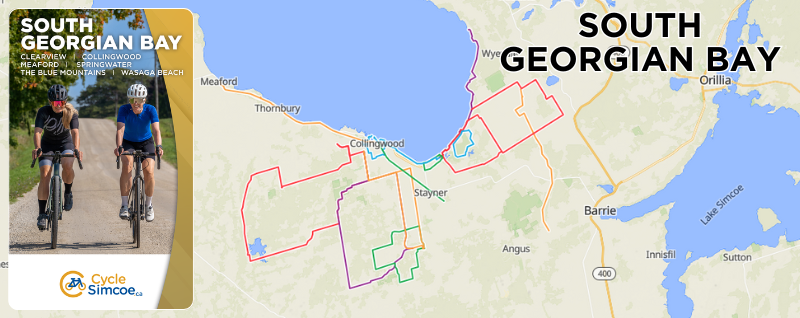
Collingwood | Wasaga Beach | Clearview | Springwater | Blue Mountain
South Georgian Bay, located only 90 minutes north of Toronto, is considered one of Ontario’s most diverse regions. The southern shores of Georgian Bay give rise to the highest point of the Niagara Escarpment, a UNESCO biosphere reserve and a haven for four-season outdoor adventure.
Experience Historic Downtown Collingwood and the quaint Town of The Blue Mountains and Thornbury lie on the edge of world-class resorts, forested trails and picturesque farmland.
Take a ride around town or in the countryside. Visit a vineyard, orchard or tour one of many local breweries. Taste the local bounty. Ride along the longest freshwater beach in the world, located in Wasaga Beach. Discover the beauty as you ride the winding roads and enjoy the vistas from the extensive rail trail network.
Home to one of the most extensive multi-use trail networks and some of the most scenic road cycling climbs in the province, South Georgian Bay offers a challenge for riders of all abilities and styles. Whether touring with friends or enjoying the fresh air with your family, we have a route for you.
For tourism information, please visit experience.simcoe.ca/south-georgian-bay


TRAILS
Carly Patterson Memorial Trail
Difficulty: Easy
Length: 11 km
Start: Wasaga Beach RecPlex, 1724 Mosley Street
The Carley Patterson Memorial Trail meanders along Trillium Creek though a mosaic of swamp and upland forests. Snowmelt in the spring creates woodland pools that support breeding habitat for migrating waterfowl. Several woodpecker species – including the rare Red-headed Woodpecker and Red-bellied Woodpecker – forage and nest along the creek corridor. White-tailed Deer and Wild Turkeys can be seen along the trail. Trillium Creek provides habitat for a handful of small fish species as well as amphibians even though flows can be very low or even intermittent during spring and early fall.
Please Note: A hybrid bike is recommended for this trail as it is a combination of quiet roads and stone dusted trail.
North Simcoe Rail Trail
Difficulty: Easy
Length: 47 km (each way)
Start: Pinegrove Road near Hwy 90 or Phelpston roadside parking
The North Simcoe Rail Trail follows the route of the North Simcoe Railway, which was built in 1878 and primarily served lumber business on Georgian Bay. The trail now offers stunning views over the Minesing Swamp and the Mayer’s Marsh, both excellent birding spots or check historic Fort Willow, and it’s Nine Mile Portage Hertiage Festival every September. The trail connects to the Tiny Trail in the north, and with the Ganaraska Hiking Trail in the south.
The Georgian Trail is a fantastic way to commute around South Georgian Bay and is safe, accessible and fun for the whole family.
Georgian Trail
Difficulty: Easy
Length: 33.6 km
Start: Collingwood or Meaford
From Collingwood to Meaford, the trail runs near Hwy. 26 West with numerous access points along the way. If you are looking for the most scenic waterfront trail in the area, the Georgian Trail has it. Running along the south shore of beautiful Georgian Bay, the Georgian Trail has ample opportunity to stop, rest and swim during the summer months.
The Georgian Trail is a fantastic way to commute around South Georgian Bay and is safe, accessible and fun for the whole family.
Clearview-Collingwood Train Trail
Difficulty: Easy
Length: 16.9 km
Start: Collingwood or Stayner
Spanning from Collingwood to Stayner, the Clearview Train Trail is a crushed gravel, linear trail connecting to the Collingwood Train Trail. It follows an abandoned rail line which used to be part of the Ontario Simcoe and Huron Railway system connecting Collingwood to Toronto and was built between 1851 and 1855. Prior to its abandonment in 1960, passengers enjoyed views of the tranquil landscape along the way. Now used as a multi-use trail, hikers and bikers can enjoy this flat railbed, stopping in either Stayner or Collingwood for lunch or a break.
ON-ROAD ROUTES
7 Beaches Route
Difficulty: Moderate
Length: 60 km
Start: Wasaga Beach RecPlex 1724 Mosley Street
Starting in Wasaga Beach and carrying on to Historic Balm Beach, this relatively flat route travels up the shore of Georgian Bay, passing beach after beach, including the world’s longest fresh water beach in Wasaga Beach. Bring your bathing suit along, because this route lives up to it’s name, “7 Beaches Route”. Take a swim in the clear blue waters of Georgian Bay at any point along the way or at the halfway point in Balm Beach. Grab a quick bite to eat and fill up your water bottles before you return via the same way back to Wasaga Beach where you can have a refreshing aprè ride swim!
Please note: This route sees high volumes of traffic in the peak summer season. If you want to avoid the crowds and have the beaches to yourself do this ride early in the morning.
Iron Bridge Route
Difficulty: Moderate
Length: 35 km
Start: Wasaga Beach RecPlex – 1724 Mosley Street
For a more scenic and rural ride, try the Iron Bridge Route. Known for being relatively flat except the small valley where iron Bridge is located, this route crosses the Nottawasaga River in three separate places along your 35km journey. At the halfway point you will travel through a cedar forest valley and cross a picturesque single lane Iron Bridge – a great place stop, take a picture and have a quick break before continuing on. After you cross the bridge you climb out of the valley back into farmland then back towards the bay, then ride along the shore line through Wasaga Beach areas 1 and 2 and back to your starting point. Make sure you check out all the beach excitement and beautiful views of Southern Georgian Bay at its finest while riding though Beaches 1 and 2.
Please Note: Shoreline roads near Wasaga Beach will be a busy during peak season. Tip, if you want to avoid the crowds and have the beach to yourself do this ride early in the morning.
Wasaga Dunes Loop
Difficulty: Easy
Length: 14 km
Start: Town Hall Parking lot – 30 Lewis Street
This bicycle loop follows 12 kilometres of roads in the Town of Wasaga Beach, using paved shoulders and designated bicycle lanes. Circling the 800 hectare ‘Dunes’ area of the Wasaga Beach Provincial Park, the Community Bike Loop contains a large system of parabolic dunes, forested with mature oak and pine which create a mosaic of wetland and upland forest habitats. The height of the dunes can be seen from Klondike Park Road, particularly at its intersection with Powerline Road at the south end of the bicycle loop.
Creemore Loop
Difficulty: Moderate/Advanced
Length: 60 km
Start: Fisher Fields Park, Collingwood
Heading counter clockwise out of the Town of Collingwood, the first portion which passes the Collingwood International Airport is relatively flat and perfect for your warm up. After crossing County Road 91 you enter more challenging rolling terrain. But the challenge is worth it, as you have multiple opportunities to view the beautiful Mad River along the way. If you are looking for an opportunity to stop and soak up the culture, be sure to take a break in Creemore, approximately half way through your ride. This town, known for it’s mouth watering restaurants and coffee shops, has art galleries, shopping and more!
On your way back in to Collingwood, be sure your legs are ready for the Fairgrounds Road climb, which is a difficult but short climb to a fantastic view of Georgian bay.
Badjeros Loop
Difficulty: Advanced
Length: 85 km
Start: Fisher Fields Park, Collingwood
Known for it’s challenging climbs and scenic landscape, the Badjeros Loop was designed for the advanced rider looking to test their abilities. The start is flat until you cross County Road 91, after which you have a series of rolling climbs to the top with a great view over Georgian Bay and then a steep drop into Creemore, a very pretty town with great cafes, restaurants, and galleries. Riders then pass through the quaint town of Dunedin before taking the long and challenging climb up to Maple Valley and Highway 124. Enjoy the view of Mennonite country, riding through Mennonite farms and churches, before you head down Pretty River Valley Road and back into Collingwood.
Please Note: There is a slight jog to cross Highway 124 – be careful since the cars do travel at higher speeds on that road. Also, Pretty River Valley Road is one of the most fun descents in the area with lots of twists and turns down this undulating road.
Lake Eugenia Loop
Difficulty: Advanced
Length: 90 km
Start: Fisher Fields Park, Collingwood
For experienced road riders looking to test their fitness, the Lake Eugenia Loop is the right choice. The Lake Eugenia Loop guides you along the beautiful landscape and up epic climbs, such as the Pretty River Valley. Stop off at the Rob Roy Museum or the Feversham Gorge for a break or carry on to the Village of Eugenia to refuel with a quick coffee. If you are a fan of butter tarts, be sure to visit the Kimberley General Store – known for welcoming cyclists with open arms, the Kimberly General Store has a gazebo, coffee and a butter tart that will charge you up for the last leg of the ride. One of the most picturesque sections of the ride is the return back into Collingwood, as it is characterized by a series of climbs that take you to the top of the escarpment, overlooking Georgian Bay, followed by a quick blast downhill into the Town of Collingwood.
Collingwood-Wasaga Connection
Difficulty: Easy
Length: 15 km
Start: Wasaga RecPlex – 1724 Mosley Street
Both Collingwood and Wasaga Beach are exciting towns to be in during the summer months – from waterfront events to concerts and festivals, you are guaranteed fun every time you visit. For those looking to travel between each Town via bicycle, two routes are recommended;
For a longer, more challenging on-road route, take the Wasaga Collingwood link to the Escarpment based routes. If you and your family are looking for a flatter, less challenging ride take the route which follows quiet streets until it reaches the heather Pathway.
Please Note: Riders looking to only cycle one direction can take the Wasaga Collingwood bus link, as it can transport bikes.
Elmvale Extension
Difficulty: Moderate
Length: 37 km
Start: Wasaga Beach RecPlex – 1724 Mosley Street
If you have a sweet tooth Elmvale is the place – home to the 2nd largest Maple syrup festival in Ontario and a fabulous bakery downtown. This route extends the Iron Bridge route through moderately flat terrain and small valleys, which will take you to downtown Elmvale to grab something sweet mid-ride. Just outside of town fill up your water bottles from a freshwater spring. Please use caution on the stretch of the road leaving the spring, as this can be a busy .5km section of HWY until you turn off on Flos Rd 11 W . This route also connects to the “Ontario Lake County” cycling routes if you would like to explore other areas of Simcoe County. With a full belly and full bottle of spring water its just rolling hills, farm fields and views of the Niagara Escarpment back to Wasaga Beach for your Apre ride Swim!!
An Ode to Creemore’s Turas Mor
Difficulty: Moderate/Advanced
Length: 38 km
Start: Creemore, ON
Test ride the Creemore Springs Turas Mór event route! A truly unique bike tour – Creemore Springs Turas Mór event takes place in the Village of Creemore on Saturday, May 23rd. Inspired by the vintage rides of Europe, Turas Mór – meaning ‘Great Journey’ in Gaelic – is a cycling journey on gravel and non-gravel roads through the challenging, yet beautiful, rolling hills of Creemore in the heart of Clearview Township. For seasoned riders to first-timers, there’s something for everyone! Creemore Springs offers three distances to choose from: 20k, 40k & 60k. Registration includes a fabulous day of cycling, local food & drink at designated rest stops along each route, a fun après back at the Brewery which includes a hearty post-ride lunch & live music, a gift from Creemore & small town hospitality from start to finish. To register for the event, please visit www.creemorespringsturasmor.com.
Please note: This route is a mix of gravel and pavement. A gravel, cyclocross, or hybrid bike is recommended for these roads.


